Most of us, if we’re lucky, have a special wild place. It might be the familiar site of childhood rambles or a wilderness visited once but remembered long afterward. It might be as pedestrian as the neighborhood park, or as stunning as the Sierra Nevada. Wherever it may be, it is a place that claims you, that pulls you out of yourself, that reminds you that you belong to nature and not the other way around.
Some people spend hours trolling guidebooks for such locations. But we went straight to the source, figuring that no one knows more about special spots than Sierra Club chapter outings leaders, who share them with fellow nature-lovers nearly every weekend. We asked ten of these world-wise volunteers for their personal favorites, the places they go to be alone and the places they take people they want to amaze or delight. Some are the trophies of hard-fought conservation battles; others remain threatened. But all of them, at least for the moment, are places where the fundamental things apply: The air is fresh, the earth is alive, the night is mysterious, and the simple act of paying attention is rewarded in surprising ways. If you haven’t yet seen it all, read on: One of these could be your special place as well.
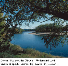
Down a Lazy River Lower Wisconsin River, Wisconsin
At the turn of the 20th century, the Wisconsin was a working river, carrying timber from the state’s forests to the Mississippi and from there to the growing cities of the Midwest. These days, the upper reaches of the river are heavily dammed, but the lower stretch runs wild, albeit at a leisurely pace. Alan Friedman, outings chair of the Great Waters Sierra Club Group, likes to put in his kayak just below the last dam, at Prairie du Sac. From there he lets the river bear him along 80 miles to its rendezvous with the Mississippi, by the rugged bluffs of Wyalusing State Park. At night he camps on sandbars, sometimes shared with noisy sandhill cranes. "There’s a stretch of about 20 miles that runs from Sauk City down to Spring Green," he says. "During the summer that stretch is busy and raucous with volleyball nets set up on the islands and floating beer parties. The rest of the year—nobody. It’s slow-moving, it’s wooded along the banks, there’s lots of wildlife, and it’s just the most relaxing place I know."
Logistics: From Madison, take U.S. Highway 12 to State Highway 78. Just past Sauk City look for a narrow road on your right that heads toward the river. There’s a boat launch and parking just below the dam.
Above It All Roaring Plains, Flatrock Plains, and Red Creek Plains, Monongahela National Forest, West Virginia
Don’t be fooled by the name. The "plains" of the West Virginia highlands are actually on the Allegheny Front, one of the highest ridges of the Appalachian Mountains. Topped by meadows, bogs, and forests of laurel and spruce, the mountains are verdant and mysterious. Their topography can attract late snow, slanting rain, and high winds, but in June the air is filled with the perfume of azaleas and music of songbirds.
Below unfolds the craggy green landscape of the mid-Atlantic. From a ridgetop, says Bruce Sundquist, the Allegheny Group outings chair and coauthor of Monongahela National Forest Hiking Guide, you can see a grand panorama taking in the south fork of the Potomac River, the Shenandoah Mountains, and the 900-foot pinnacle known as Seneca Rocks. At other times, he says, all you can make out is "a sea of fog, with the mountaintops peeking out. It’s a neat adventure just to watch the clouds tumble about in the sky."
Plains fans are pursuing wilderness designation for the area, which is threatened by logging, acid rain, and a proposed ski resort. Sundquist hopes that more visitors will mean more advocates.
Logistics: Sundquist recommends going in early- to midsummer and being prepared for wind and rain. Try the South Prong Trail: From Petersburg, West Virginia, take State Route 28/55 south to Jordan Run Road. Turn right for one mile, then left on Forest Route 19. For more information, visit www.wvhighlands.org.
Keep Your Hands in the Canoe Lake Charlotte Swamp, Texas
On the outskirts of Houston, adjacent to Lake Charlotte and just past a dreary landscape of belching refineries, an enchanting offshoot of the Trinity River system flows into Galveston Bay. One spring, Lone Star Chapter chair David Toner canoed this swamp with noted lepidopterist Robert Michael Pyle, who declared the unlikely area "a cathedral of nature."
The swamp is a nesting site for snowy egrets, and as Pyle and Toner paddled, they were surrounded by pale-white birds tending to their young in the low cypress branches. Pyle spotted butterflies, including a black witch moth, which he had never seen in the wild. When he wondered if they might see a water moccasin, Toner obligingly steered down a slough where they promptly ran up onto the back of a 12-foot alligator. "Roused from its slumber," Toner recalls, "the alligator torpedoed through the water, raising the bow of the canoe, though fortunately not overturning it."
Logistics: Toner and Pyle put in at the junction of Trinity River and I-10 east of Houston and headed upstream a quarter-mile to Lake Pass, on the east side of the Trinity River. You can also start at Cedar Hill Park on the east side of Lake Charlotte. If you’re not accustomed to navigating alligator-infested swamps, the Houston Regional Group of the Sierra Club and the Houston Canoe Club offer guided trips. If you go on your own, you’ll want a good compass (or GPS if you’re so inclined) and map. Read instructions for safe and scenic paddling at www.kayakguide.com.
A Tight Squeeze Pisgah Lava Tubes, Mojave Desert, California
Twenty-four thousand years ago, as lava flowed from Pisgah Crater, the outer layers of molten rock cooled and hardened, while the inner layers kept flowing. The result is the Pisgah lava tubes, a network of more than 80 tunnels in the eastern Mojave Desert. The largest is more than a thousand feet long and is tall enough to walk through; others you have to crawl through on your belly. One cramped passageway leads down into a chamber large enough to play a half-court game of basketball.
Bill Spreng has been visiting the tubes for years–he’s slept in them, wriggled through them, and even broken his ankle dropping eight feet down into one from an overhead opening. Unable to stand tall enough to hoist himself out, he ended up crawling through the tube until he found a skylight exit; he then had to hike a mile and a half across a lava field to the car without losing track of the six young 4-H clubbers who were accompanying him.
Despite this misadventure, Spreng’s enthusiasm for the place remains undimmed. "There’s one tube that we go into–you have to crawl around on your hands and knees for most of it," he says. "There’s a spot where it’s about a foot and a half tall. We lie on our backs on the cool sand and talk. It’s fun just lying there in the darkness talking."
Logistics: Pisgah Crater is about 40 miles east of Barstow, but there’s no trail to the tubes. Spreng leads trips there for the Sierra Club’s Mojave Group, usually in the spring. (The desert gets unbearably hot in the summer.) Contact him to find out when the next one is planned: (760) 951-4520 or bspreng@gte.net.
The White Cliffs of Utah Notch Peak Wilderness Study Area, House Range, Utah
Notch Peak’s claim to fame is its limestone cliff, at 4,450 feet one of the highest vertical faces on the continent. But there’s more to this desert wilderness: unexpected groves of aspen, limestone dolomite caverns, and bristlecone pines that are among the oldest living things on Earth. "It’s a magical place," says outings leader Kurt Alloway. "You can hike up Box Canyon Gorge; once you’re at the bottom you look at this cliff and it’s like Yosemite rising up in front of you. And you’re standing in a little Douglas fir grove in the midst of an otherwise barren desert."
Cougars and coyotes prowl the wilderness, hunting pronghorn and mule deer. Badgers burrow below, eagles and falcons soar above. Humans have long appreciated its charms: There are archaeological sites dating back to the Clovis era some 11,000 years ago, when the valley held a lake and people still hunted mammoth.
Alloway has found that the folks he takes out to Notch Peak tend to form bonds that last well after the journey. "It’s the dynamics of that desert," he says. "It’s such a powerful place it can inspire poetry and, in some cases, lifetime friendships." He hopes that visitors will become advocates for the area, which is threatened by mining, off-road vehicles, and a proposed military training range.
Logistics: Come in the early spring or late fall, when temperatures are manageable. Take U.S. 6/50 west from Delta, Utah (about 135 miles south of Salt Lake City). Turn onto the gravel road at mile marker 46, and go five miles to Miller Canyon Road. Follow Miller Canyon another five miles to Sawtooth Canyon and turn left. Continue two miles until you can’t drive anymore. There’s no trail to the 9,600-foot summit, so bring a topo map. For details, see www.ut.BLM.gov/wilderness/wrpt/wrptwcnotch.html.
Mangrove Maze Matlacha Pass National Wildlife Refuge, Lee County, Florida
Matlacha Pass is a labyrinth of red mangroves, where mangrove crabs scuttle along the branches and manatees sometimes nibble on the rope handles of your kayak. Despite its name, Matlacha Pass is an estuary between Pine Island and the mainland near Ft. Myers, Florida, part of the Charlotte Harbor National Estuary. More than 300 bird species gather here, among them the roseate spoonbill, white ibis, snowy egret, and six varieties of heron.
If stretched end to end, the mazes would cover 500 miles. Some of the tree-lined tunnels are so tight they are only passable at mid-tide. "You can definitely get lost in there," says Connie Langmann, outings chair for the Sierra Club’s Calusa Group, who leads paddle trips through the area, sometimes by moonlight. "The tunnels go on and meander, and then there’s another one, and it meanders, and on and on. I was blessed with an excellent sense of direction, and now I’m using it."
Logistics: Access is by boat only, and care must be taken not to damage the fragile seabeds. The estuary is located eight miles northwest of Fort Myers. Good sources of information are the J. N. "Ding" Darling National Wildlife Refuge in Sanibel, at (239) 472-1100 or http://southeast.fws.gov/MatlachaPass, or www.calusablueway.com. You can contact Langmann at www.GAEAguides.com.
Roger Singer, a regional representative for the Sierra Club in Idaho, calls the Owyhee Canyonlands "one of the biggest blank spots left on a map of the American West." The area’s more than 8 million acres are spread across three states, with scarcely a paved road, parking lot, or developed campground among them.
"You can explore on your own, and find that solitude and quiet that is disappearing across the West," Singer says. "You might suddenly come across a galloping herd of pronghorn or, in the canyon country, hear rocks falling and look up to see a bighorn sheep scrambling up a cliff."
The landscape is wildly diverse, with river canyons rimmed by rosy igneous rock, juniper-covered peaks that rise nearly 9,000 feet, and a sagebrush ocean interrupted by a maze of the towering 150-foot spires known as hoodoos.
Logistics: The trailhead for Leslie Gulch, home of the hoodoos, is off U.S. 95 just north of Jordan Valley, Oregon, and down 25 miles of dirt road.
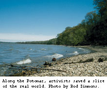
It was once slated to be a bustling business center, but instead it’s one of Maryland’s wildest places: a dense, lush forest of old-growth trees and nesting bald eagles, pileated woodpeckers, and wild turkeys. Its two miles of Potomac River shoreline lure ospreys, green and great blue herons, and Louisiana waterthrushes. In combination with surrounding public lands, Chapman Forest creates an oasis of over 13,000 contiguous acres of protected area south of the nation’s capital. This elbow room, combined with ancient shell deposits that sweeten the soil, have nurtured a crazy quilt of plants–prickly pear cactus growing next to woodland swamps, a panoply of ferns, dozens of endangered plants, and, in the spring, 20 species of wildflowers blooming simultaneously. "I don’t know of any other place that has so many kinds of violets and orchids at one spot," says Chapman partisan and Sierra Club outings leader Marc Imlay.
Logistics: Spring is the ideal time to visit these woods. Take the Capital Beltway to Maryland Route 210 south. Just over a mile past the Maryland 227 traffic light, turn right on Chapmans Landing Road and follow it to the park entrance.
You’ll Need a Compass Indian Creek, Buffalo Gap National Grasslands, South Dakota
Fewer than 50 people a year visit Indian Creek, a 24,000-acre potential wilderness inside Buffalo Gap National Grasslands, so there’s room for a few more. With no roads or marked trails, this place attracts only those who own a compass and a sturdy pair of boots. Part of the Great Plains’ largest remaining wildland, it’s an austere landscape of open, hilly country, rippled with juniper-lined draws. Coyotes roam the canyons, along with pronghorn and white-tailed and mule deer.
"You can walk into the middle of this and there’s absolute, total peace and quiet," says South Dakota Sierra Club Chapter chair Sam Clauson, who likes to come in November to watch the annual Leonid meteor shower spatter the enormous sky with streaks of light. "You can imagine you’re no longer on Earth, it’s so unworldly."
Logistics: From Rapid City, take Highway 44 east to the town of Scenic. From there, take County Road 580 to Forest Service Road 7129. Clauson recommends coming in late spring or fall; by midsummer, temperatures top 100 degrees.
What a Little Moonlight Can Do Central Park, New York City
Once a month, Larry Stack leads 50 New Yorkers on a nighttime hike in a wild place many of them have never explored: Central Park. They walk the perimeter, a distance of about six miles. "Basically it’s to look at the trees at night," Stack says. "The park becomes so beautiful, it glistens, and the quietness that you don’t usually attribute to New York City comes out. It’s just so peaceful. That was the purpose of the park when it was built in the mid-1800s, to give you that sense of peacefulness. It’s a chance to rekindle the innocence that is so badgered so much of the time."
Logistics: Stack’s night hikes begin at 8 p.m. and are usually followed by dinner; you can contact him at LStack@concentric.net. More information is at www.centralpark.org.
Explore You can enjoy hundreds of special places year-round with the Sierra Club’s Outings program. For daylong or weekend excursions close to home, check out your local Sierra Club group or chapter newsletter. For more far-flung adventures, contact the National and International Outings program, which conducts over 350 trips across the globe; consult the listings in Sierra, call (415) 977-5522, or visit www.sierraclub.org/outings.

 At the turn of the 20th century, the Wisconsin was a working river, carrying timber from the state’s forests to the Mississippi and from there to the growing cities of the Midwest. These days, the upper reaches of the river are heavily dammed, but the lower stretch runs wild, albeit at a leisurely pace. Alan Friedman, outings chair of the Great Waters Sierra Club Group, likes to put in his kayak just below the last dam, at Prairie du Sac. From there he lets the river bear him along 80 miles to its rendezvous with the Mississippi, by the rugged bluffs of Wyalusing State Park. At night he camps on sandbars, sometimes shared with noisy sandhill cranes. "There’s a stretch of about 20 miles that runs from Sauk City down to Spring Green," he says.
 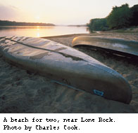 "During the summer that stretch is busy and raucous with volleyball nets set up on the islands and floating beer parties. The rest of the year—nobody. It’s slow-moving, it’s wooded along the banks, there’s lots of wildlife, and it’s just the most relaxing place I know."
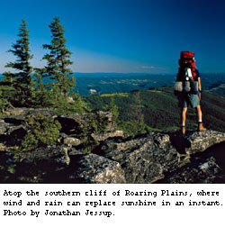 Don’t be fooled by the name. The "plains" of the West Virginia highlands are actually on the Allegheny Front, one of the highest ridges of the Appalachian Mountains. Topped by meadows, bogs, and forests of laurel and spruce, the mountains are verdant and mysterious. Their topography can attract late snow, slanting rain, and high winds, but in June the air is filled with the perfume of azaleas and music of songbirds.
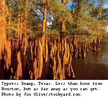 On the outskirts of Houston, adjacent to Lake Charlotte and just past a dreary landscape of belching refineries, an enchanting offshoot of the Trinity River system flows into Galveston Bay. One spring, Lone Star Chapter chair David Toner canoed this swamp with noted lepidopterist Robert Michael Pyle, who declared the unlikely area "a cathedral of nature."
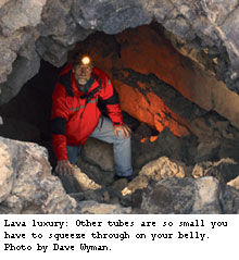 Twenty-four thousand years ago, as lava flowed from Pisgah Crater, the outer layers of molten rock cooled and hardened, while the inner layers kept flowing. The result is the Pisgah lava tubes, a network of more than 80 tunnels in the eastern Mojave Desert. The largest is more than a thousand feet long and is tall enough to walk through; others you have to crawl through on your belly. One cramped passageway leads down into a chamber large enough to play a half-court game of basketball.
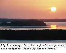 Matlacha Pass is a labyrinth of red mangroves, where mangrove crabs scuttle along the branches and manatees sometimes nibble on the rope handles of your kayak. Despite its name, Matlacha Pass is an estuary between Pine Island and the mainland near Ft. Myers, Florida, part of the Charlotte Harbor National Estuary. More than 300 bird species gather here, among them the roseate spoonbill, white ibis, snowy egret, and six varieties of heron.
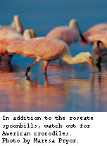 If stretched end to end, the mazes would cover 500 miles. Some of the tree-lined tunnels are so tight they are only passable at mid-tide. "You can definitely get lost in there," says Connie Langmann, outings chair for the Sierra Club’s Calusa Group, who leads paddle trips through the area, sometimes by moonlight. "The tunnels go on and meander, and then there’s another one, and it meanders, and on and on. I was blessed with an excellent sense of direction, and now I’m using it."
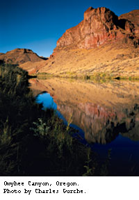
 It was once slated to be a bustling business center, but instead it’s one of Maryland’s wildest places: a dense, lush forest of old-growth trees and nesting bald eagles, pileated woodpeckers, and wild turkeys. Its two miles of Potomac River shoreline lure ospreys, green and great blue herons, and Louisiana waterthrushes. In combination with surrounding public lands, Chapman Forest creates an oasis of over 13,000 contiguous acres of protected area south of the nation’s capital. This elbow room, combined with ancient shell deposits that sweeten the soil, have nurtured a crazy quilt of plants–prickly pear cactus growing next to woodland swamps, a panoply of ferns, dozens of endangered plants, and, in the spring, 20 species of wildflowers blooming simultaneously. "I don’t know of any other place that has so many kinds of violets and orchids at one spot," says Chapman partisan and Sierra Club outings leader Marc Imlay.