Eyes in the Sky and on Your Desktop With Google Earth, satellite images become an activist's ally
By Gregory Dicum
September/October 2007
LATE IN 2005, REBECCA MOORE WAS GIVING a presentation to a community group concerned about proposed logging in the Santa Cruz Mountains, south of San Francisco. In the darkened room, a large screen displayed an image of Earth floating serenely in space.
Moore touched a key on her computer, and the planet expanded to fill the screen. As the view zoomed closer still, the more than 300 audience members were able to make out the California coastline, then their own region. The landscape tilted, and the flat imagery leaped up to form mountains and valleys. Finally, they could see detailed three-dimensional satellite images of the redwood-covered ridges above their homes.
Moore touched another key and added an overlay of the proposed logging plan. The audience gasped. Suddenly, the grainy sketch a timber company had presented as a fire-prevention measure was revealed for what it was: a commercial logging operation that would deplete the forests adjacent to the community's homes and schools and threaten the drinking water of more than 100,000 people.
"It electrified the room," recalls Moore, who had developed the presentation in just a few days using Google Earth, a free desktop application that lets anyone with a modern computer explore a breathtakingly detailed digital model of the planet.
Because Google Earth drapes satellite imagery over 3-D topographic data, the program creates the illusion of flying over a landscape. The "pilot" gets an intimate, intuitive understanding of how a place is laid out. Users can create explanatory annotations--like cartoon "speech balloons"--and layer them on top of Google's geographic data. They can then share this information with others.
Several years ago, Moore, a computer programmer, was living in the Santa Cruz Mountains when local land-development issues spurred her to experiment with digital mapping. First using off-the-shelf consumer software, then professional geographic information systems (GIS), Moore took the initiative to create a computer-generated map for local counties, first responders, the state Department of Forestry, and others.
"They got really excited," Moore says, but she remained frustrated by the expense and awkwardness of the GIS software. In 2004 she stumbled on Earth Viewer, an elegant Web-based satellite-imaging program developed by a company called Keyhole. When Google bought Keyhole later that year, Moore went to work for Google--her hands-on ideas for practical applications were just what the company needed.
Google lets its programmers spend a fifth of their salaried time working on side projects of their own choosing, and Moore quickly became the liaison between Google Earth and the environmental community. The wow factor of her Santa Cruz Mountains simulated flyovers became her calling card: Using Google Earth, Moore demonstrated that the logging company owned too much land to qualify for the type of operation it had proposed, and the logging plan was withdrawn. (Moore hopes the land may soon be protected as part of a regional park.) Once word of that success spread, Moore was inundated with queries from activists all over the world.
Since then, environmental organizations have embraced Google Earth in inventive ways. Applications include displaying near-real-time Arctic and Antarctic ice floe information, cataloging threatened habitat around the planet, tracking the movements of large animals, scrutinizing proposed land-use plans, and keeping an eye on oil and gas development. The Amazon Conservation Team, for example, uses Google Earth to monitor illegal mining and logging in the Amazon basin. Indigenous groups use it to search for suspicious features such as clandestine airstrips and riverside sluice boxes, then travel to the sites equipped with global positioning system devices to assess what is going on. Such detailed evidence, in turn, prods authorities to take action.
While Google Earth is no substitute for GIS software when it comes to analyzing mounds of data, it perfectly fills a gap in explaining environmental issues to the public, depicting problems and solutions on a comprehensive but accessible model of Earth. And the program puts a tremendous amount of satellite and elevation data into the hands of ordinary citizens. "Suddenly grassroots environmentalists have a tool that up until now only government agencies or commercial interests had," says Moore. "It levels the playing field."
Google Earth was adopted so rapidly by the environmental community and others that this year the company launched a "Global Awareness" component that lets any of the 200 million Google Earth users explore data from a selected handful of projects, some of which are highlighted here.
"I think that this has the potential not only to raise people's environmental consciousness but to raise their consciousness of humanity," says Moore. "I see it as making the world a smaller place in a good way--giving everyone a greater intimacy with the earth."
Image by Google Inc./Sierra Club
Arctic Alaska Up Close
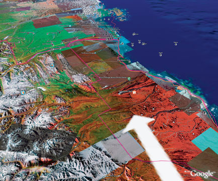
The Sierra Club was one of the first national environmental organizations to take advantage of Google Earth. Adrian Cotter, the Club's senior webmaster, used the program in late 2005 to create an annotated map of the Arctic National Wildlife Refuge that draws together data ranging from the locations of oil wells to the porcupine caribou herd's migration route (arrow above). The presentation, which became one of the Club Web site's most popular downloads ever, includes information about the ecosystems of the North Slope, the boundaries of wild and developed areas, and links to photos and videos.
"When I saw all that data together in Google Earth, I had an aha moment," recalls Cotter. "Alaska is huge, so being able to put the Arctic Refuge in context and show that the rest of the coast is already covered in oil wells was the most jaw-dropping thing. You can say there are 6,000 wells, but until you see it, it doesn't have the same impact." For more information, go to sierraclub.org/arctic/maps.
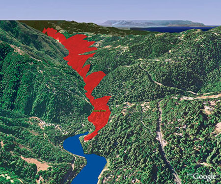
Image by Google Inc./Rebecca Moore
Seeing the Forest for the Unlogged Trees
The Google Earth presentation Rebecca Moore created for the Mountain Resource Group, a grassroots organization working to preserve redwood forests in the Santa Cruz Mountains, is one of the best around. It includes a low-elevation flyover showing individual trees that were slated to be axed (in red, above) and crucial information like the locations of streams, schools, and reservoirs. What's more impressive is that people without Moore's programming skills can use the software to get dramatic results.
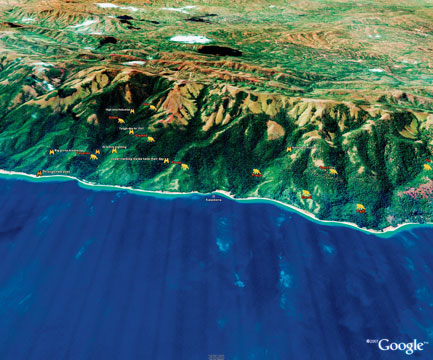
Image by Google Inc./Jane Goodall Institute
Keeping an Eye on Poachers
The Jane Goodall Institute had a problem: Data on chimpanzee poaching was being collected in Uganda and Tanzania, but the GIS analysis of that information was being done in Minnesota. As a result, field staff didn't have access to the analysis they needed to make quick decisions.
Lilian Pintea, the institute's director of conservation science, wants to bring more-advanced GIS capabilities to the field, but that's at least two years away. Instead, he says, staff in Africa took matters into their own hands and began using Google Earth to map the locations of chimpanzee-poaching snares they discovered in the forest. One goal is to plot the snares' distance from the schools where the organization is doing environmental education, to see if its efforts are reducing poaching.
Pintea convinced a private satellite company to donate extremely high-resolution data. This imagery, from Tanzania and Uganda, is now visible to any Google Earth user. The institute maintains a blog (janegoodall.org/gombe-chimp-blog) where users can read about and see photos and videos of individual chimps, and follow their lives on a daily basis with Google Earth.
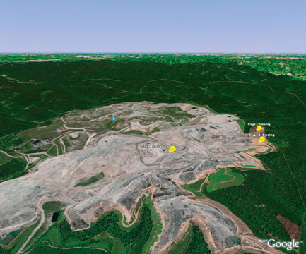
Image by Google Inc./Appalachian Voices
No Way to Hide
People without access to a seat on a Cessna can still get a bird's-eye view of the devastation of mountaintop-removal mining using Google Earth. Appalachian Voices, an organization dedicated to exposing and stopping the practice, maps mining damage and shows which intact mountains are slated for removal (see ilovemountains.org). Nobody knows the true extent of the problem, says Matt Wasson, the group's conservation director, but Appalachian Voices has already documented 900,000 acres destroyed. "Most people think the government is tracking this information," he says, "but it isn't. The data is very bad."
Google Earth has been a boon for the tiny groups Appalachian Voices works with. "Community groups in the coalfields really have no resources," Wasson says. "They're thrilled to have this capacity."
Gregory Dicum is the author of Window Seat: Reading the Landscape From the Air (Chronicle Books, 2004).
For Google Earth case studies, including details on the Sierra Club's efforts to educate the public about the Arctic National Wildlife Refuge, go to earth.google.com/outreach.