|
An unassuming sinkhole in a patch of Tongass old growth leads to a wonderland of limestone caverns.
By Bruce Brewer
SIDEBAR: Not Caving In
Photograph by Bruce Brewer
With blue skies and temperatures in the 80s, southeast Alaska doesn’t feel like a rainforest. Dappled sunlight dances through spruce and hemlock branches swaying 150 feet overhead in the mid-June breeze. In the muskegs–the sponge-like bogs that ring the old-growth forest–shooting stars are in bloom, their purple blossoms dotting a lime-green carpet of sphagnum moss.
Black bears forage along gravel logging roads and dart into the forest when humans approach. To the south, the shadowy peaks of Heceta Island rise through the humid sea air across Davidson Inlet.
It’s a perfect shorts and T-shirt day for a leisurely hike, or a ride in a skiff to watch sea otters bob in the gleaming, cool waters of nearby Edna Bay.
But not for us.
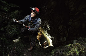
Instead, my team and I are wrapped in expedition-weight polypropylene, fleece, wool socks, and armored bodysuits made of ballistic nylon and PVC. We enjoy no sun, no warm breeze, and no scenic vistas. We sweat, not from the warmth, but from exertion. The perspiration steams out of our suits into musty air that smells of earth.
We’re in Tongass National Forest. Or more precisely, 60 feet beneath it, exploring a newly discovered cave on Kosciusko Island, one of a thousand or so islands that are part of the Tongass. With other volunteers working with the U.S. Forest Service, I’m helping locate and map a vast network of limestone caves. So far, more than 600 caves have been found and charted in the Tongass–but that number is thought to be a tiny fraction of what’s here.
Because of the insulating qualities of the earth, the cave we’ve dropped into maintains the mean average temperature of the region, about 40 degrees, even as the land above us bakes. Beneath tons of solid rock our dim headlamps provide a pale yellow glow in a place that has never known sunlight. Our breath vaporizes as it passes through balaclavas and into the cold, humid subterranean atmosphere.
As the caving population has grown in recent decades, so too has research and activism. More people are experiencing caves as windows into a complex environment where water flows not just over land, but through it. Caves harbor unique life, act as archaeological repositories, and are important sources of water.
On a more visceral level, caves are just plain awesome landscapes, as inspiring as Yosemite’s El Capitan or the sea of grass in Florida’s Everglades. Of course, a cave is much harder to visit: Underneath the Tongass, you have to be ready to crawl, climb, squeeze, and swim.
The cave we’re mapping, known only as K-109, begins as a hole a little wider than a basketball hoop at the base of a grove of old growth. From that humble beginning we descend into a sinuous, narrow canyon whose walls are covered in "moon milk," a rare white bubbly coating made of calcite.
In places the ceiling is 15 feet high, but the walls are only a foot apart. As we slide through pinch points our clothing grinds against walls with the texture of rough cement. Here and there we have to drop to our knees and move sideways, ducking under pinches too narrow for our helmeted heads.
The slot ends abruptly at a 15-foot drop into a silo-shaped chamber. We rig a rope and carefully shimmy to the floor, where a few white "soda straws," or crystal tubes, hang over our heads. A trickle of water flows in from a small side passage up one wall, bringing sloppy black mud from the surface. Our voices ricochet and reverberate off the curving walls, making conversation difficult. Following the water, we slide down another crack and come to a standing space with smooth, white crystal walls coated with liquid-looking flowstone. From there, we climb down into a two-foot-wide fissure, only to find it’s another drop, this one piercing the ceiling of a large chamber. The misty air and the curving walls of the fissure obscure the bottom. All we know is that the chamber is big, or so our echoes suggest. There’s only one way to find out what’s there.
Gino Albert, a caver from Chicago, ties an 11-millimeter nylon rope around a rock outcrop and lowers it down the fissure. He then threads the rope through his rack, a steel device resembling a foot-long ladder. The rope weaves around the bars, producing friction that allows a caver to slide in a controlled manner.
Gino wiggles downward, keeping one hand on his rack for control. Then he disappears from view. The seconds crawl by. The trickle of water gurgles behind me as the rope bobs and shakes from his motion. He finally sends back a report.
"Oh my God! I don’t believe this! This is the best cave on the island! It looks like Arizona!" he yells, referring to the heavily decorated caves found there.
"Are you off-rope?"
"No!"
"Well get off the damned rope!" is all I can muster. I can’t begin my descent until he does.
When I finally drop into the chamber and turn to face the room, Gino is still ecstatic. We’ve broken into a three-way intersection of 20-foot-wide tunnels with 20-foot-high ceilings. The whole passage plunges at a 45-degree angle into the bedrock. The walls, floor, and ceiling bristle with accretions of crystallized minerals that have been leached out of the rock by percolating water and deposited over thousands of years, making the chamber look like something out of a Dr. Seuss book.
At the center of the junction a seven-foot-tall stalagmite rises from the floor like an ancient tooth, its base covered in bumpy crystal nodules. Along the right-hand wall a line of stalactites stabs downward from the ceiling. An alcove is filled with a forest of foot-tall, white stalagmites resembling melted candles. Clear soda straws dangle from overhangs on either side of the passage, their hollow tubes created when water dripped from the ceiling in one spot for centuries, leaving a buildup of crystal residue behind.
While we expected to find these kinds of formations, we didn’t expect such abundance–or less familiar ones, like the amazingly long crystal drapery that hangs above our heads. Such a formation is created when drops of water slide along an angled ceiling, leaving an ever-thickening line of calcite residue. The mineral builds up until a curtain of crystal is left behind, undulating like fabric frozen in a subzero wind. If the mineral or organic content of the water changes over time, the deposit changes color, creating a banded effect.
We’ve found what is unquestionably the most decorated cave ever explored on the island. The central stalagmite will eventually be determined to be one of the largest formations found in any cave in the entire Tongass.
Leaving the formations behind, we follow the main trunk passage deeper into the earth. Its steeply sloped funhouse floor is covered in a stream of baseball-size rocks that roll and shift as we walk over them. We swing our arms like clumsy skaters and reach for support against boulders that wobble at the touch. While the walls are clean, the floor is covered with thick mud from the muskegs on the surface. We turn a few corners and I stop and look at Gino. He pauses. He doesn’t hear it yet.
When the gurgling, bubbling sound of the underground stream reaches him, we burst into cheers. The rivulet enters the cave through a hole in the ceiling, cascades down the far wall and then follows a chute into the darkness. We’ve found one heck of a cave.
Cavers have traditionally been a tight-lipped bunch, relying on secrecy to protect our favorite retreats, the ages of which are measured in tens or hundreds of millennia and which–despite origins in rock–are often fragile. Too many visitors, vandalism, and theft of formations like stalagmites have always been threats. But these days, local kids with spray paint and rock hounds with hammers are trivial compared with mining, sprawl, and, in the case of the Tongass, logging.
In 2001, the central Tennessee town of Spencer found itself in the national spotlight over its new sewage-treatment plant. Cavers announced they had found a cavern beneath Fall Creek Falls State Park with a 20-story chamber long enough to house a half dozen 737 jets nose-to-tail. In addition, 24 species of wildlife, including cave crayfish and four types of beetles, lived in the cave. But the town’s treated sewage water would have flowed directly into it. Public pressure and legal rulings eventually forced a temporary switch to a less destructive plan.
At about the same time, a proposed rock-quarry expansion was threatening a wild area in north Georgia. Vulcan Materials Company owned the mineral rights to 800 acres of state-owned land on Pigeon Mountain, about two hours northwest of Atlanta. While hikers and hunters opposed the expansion first, the real battle cry came when cavers found a new 225-foot-deep pit (Georgia’s second-deepest) with wall-to-wall crystal formations.
Now cavers’ worries center on Tongass Forest’s 17 million acres. For some 50 years, industrial logging of its moss-covered trees has been a source of lawsuits, investigations, conservation campaigns, and political wrangling. Environmentalists argue that the logging is unsustainable, harms salmon spawning grounds, is an economic drag on taxpayers, and overshadows all other uses. With shocking photographs, they’ve been able to show people exactly how an ancient forest can be reduced to a tangled mess of stumps and second growth.
But while millions of people were looking up, few thought to look down. Most of the outer islands of the southern Tongass are made of limestone, a relatively soft, porous rock. The region’s 100-plus inches of rain a year mixes with carbon dioxide from rotting vegetation, and becomes slightly acidic. Over millennia the water has bored an intricate network of geologic veins through the bedrock. The result is a landscape of sinkholes, springs, disappearing streams, and caves.
This landscape is called karst, and the Tongass contains one of the richest karst topographies on Earth. Its caves are also storehouses of important archaeological material. While constant rain and dense forest make preservation of artifacts virtually impossible above ground, caves have protected 41,600-year-old black bear skeletons and 9,800-year-old human remains that are altering theories of human migration to the Americas. Prior to these discoveries it was believed all of southeast Alaska was covered in glaciers during the last ice age. But cave-stored evidence now suggests that a portion of this coast was ice-free, amenable to both animals and humans migrating into the continent.
The drainage and mineral content of karst makes it the most biologically productive land in the Tongass. The mineralized water in salmon spawning grounds allows the fish to grow faster and healthier than those in non-karst streams. The excellent drainage also allows spruce, hemlock, and cedar to grow to massive size.
Logging can change the way water flows into caves, clogging them with slash and silt, and allowing dense second-growth to make access impossible. While the Forest Service is supposed to take all this into consideration when planning a timber sale–mandating buffer zones around caves and sinkholes and avoiding vulnerable areas altogether–until recently the agency rarely did. When cavers’ data showed that the Forest Service had performed only cursory karst investigations on the Tongass’s Heceta Island in 1999, the agency was forced to restructure a huge timber sale. That year, interest turned to Kosciusko, which was named one of the top ten endangered karst systems in the world by the Karst Waters Institute, a nonprofit organization that advocates karst protection worldwide.
We’re standing on a logging road by a dry creekbed next to a logging area. According to our aerial photos, the stream flowed infrequently before the watershed was logged. Now it flows more often and in greater volume.
Hydrologist Tom Aley of Missouri’s Ozark Underground Laboratory suspects that logging debris has clogged openings connecting to the underground drainage system, but without baseline data there’s no way to know.
Volunteer cavers have been inventorying and mapping caves below proposed logging units throughout the Tongass since 1988. The first years were filled with optimism, particularly when the Forest Service declared Tongass karst a "nationally significant" resource in 1993. But by decade’s end, many cavers saw that logging was continuing apace and concluded that "above ground" conservationists like the Sierra Club were right: Forest Service cooperation was a smoke screen to get the timber out.
A new round of logging is being planned on Kosciusko Island, one that calls for more than five miles of permanent roads and a target of 26 million board feet of timber, enough to build 1,980 houses. While the Forest Service boasts that it has trimmed the original proposal by three-quarters to protect karst, cavers say they’ve already found double the number of caves the Forest Service knows about. In a letter to the Tongass district ranger, the Alaska chapter of the National Speleological Society called the plan "irresponsible" for providing no monitoring of logging’s effects and for lacking protective buffers around many cave entrances. The cavers’ recommendation: Halt all logging on units known to have caves, underground streams, and other karst features.
With Tongass National Forest geologist Jim Baichtal, I tour the old growth around cave K-109, an area cavers call the "Hot Spot" for its underground wonders. Baichtal assures me that the Hot Spot is off the chopping block. One of our karst experts asks for how long. Baichtal backtracks: as long as he’s in the Tongass.
The remark illustrates the dilemma in southeast Alaska. Half of the Tongass’s most productive land has been logged, but up to 80 percent of karst terrain has already come under the ax. The number of caves like K-109 that have been lost is unknown. The number of archaeological sites destroyed is anyone’s guess. Recreational opportunities and salmon-nourishing springs? Who knows?
On a third trip into K-109, we go deeper. The cave’s main passage alone is about 1,000 feet long, its lower third covered in mud, indicating that it floods. We rig ropes to rappel a series of short drops over massive boulder chokes and then enter the final chamber: a funnel-shape room with a 30-foot ceiling. At the base of the room the stream trickles down the stair-step drop and into a mud-filled hole three feet across and then disappears.
The cave continues, but not for us. One huge passage is boring its way steeply toward the surface, but a 15-foot-deep fissure crossing its base would make climbing the slope too dangerous; one misstep and we’d slide straight down into the drop. Another precipitous passage comes to a landing with vertical shafts disappearing into the ceiling. All promising, but it’s time to leave. Other areas need to be inventoried. I clip an ascender to the rope and begin my climb out, leaving K-109 to the darkness.
Bruce Brewer is a writer, photographer, and caver based in Tallahassee, Florida.
Up to Top | Not Caving In
|