Profile: Captain Conservation He's charting a course to save Mississippi's coastline By Marilyn Berlin Snell
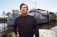
Tour-boat operator Louis Skrmetta collects Elvis memorabilia, Civil War tales, and stories about the Gulf Islands National Seashore, where his family has worked for three generations.
When Louis Skrmetta's grandfather began captaining one of the first tour boats to Dog Key Island off the coast of Mississippi in the 1920s, Prohibition was in full swing. An immigrant from a Croatian fishing village, "Captain Pete" used the oyster and shrimp off-season to ferry clients to the Isle of Caprice Hotel and Resort. The establishment was just outside U.S. jurisdiction in the Gulf of Mexico and a lovely spot for visitors to while away the hours drinking, gambling, and watching flappers do the Charleston at the speakeasy there.
Strong ocean currents, raging storms, and the tendency of visitors making flower arrangements to pick the sea oats that stabilized the island's sand eventually submerged Dog Key. But the ferry operation continues into the third generation with Skrmetta, 50, and his three younger brothers. "Our family has been attached to these barrier islands for so long," says Skrmetta. "I remember sleeping on pallets on the picnic tables as a kid. My aunts and grandmother ran the snack bar and restaurant out on Ship Island, while my dad, the second Captain Pete, and grandfather ran the boats. At night on the island, they'd turn the generator off and everything would be so quiet. No lights but the stars. It was beautiful."
Today seven barrier islands are part of the Gulf Islands National Seashore, a federally protected area that stretches 160 miles from Mississippi's Cat and West Ship Islands to the far end of Santa Rosa Island in Florida. (The boundaries don't include Alabama's barrier islands, at the request of then-governor George Wallace in 1971.) The Skrmettas have the sole National Park Service concession on West Ship Island. From March through October, they take as many as 1,200 visitors a day to some of the most pristine beaches on the Gulf Coast--part of what some locals affectionately call "the redneck Riviera." On the 22-mile round-trip from Gulfport, Mississippi, to West Ship--75 cents in the original Captain Pete's day, $20 today--sightings of Atlantic bottlenose dolphins are common. Folks can stay on the island until the last boat leaves at 5 p.m., walking the eight miles of shore, swimming, fishing, beachcombing, or touring Fort Massachusetts, built in the 19th century to protect New Orleans from attacks by sea. In a little under an hour, ferry passengers can leave behind civilization and its mechanized discontents: There are no motorized vehicles on West Ship; Jet Skis are prohibited in national seashore waters.
Weather is always a threat to the delicate islands. Hurricane Camille cut Ship Island in half in 1969, creating West and East Ship Islands; Katrina demolished the historic lighthouse and most of the Park Service structures. These days, danger also comes from stealth legislation that would allow oil and gas drilling in and around the national seashore. Skrmetta, a history buff who, when not guiding visitors, would like nothing better than to be left alone with his Civil War books, has made it his business to protect the place from energy exploitation's gathering storm.
Last year, Louisiana and Alabama together produced 404 million barrels of oil and 2.8 billion cubic feet of natural gas from their offshore facilities. Many in the oil and gas industry believe Mississippi's coastal areas could hide similar riches. Others say the state's real treasures are already visible and would be destroyed by such development.
"To understand why we don't want drilling on the national seashore, all you need to do is take a look at Alabama's Dauphin Island," says Skrmetta. When then-governor Wallace exempted his state from federal protection, he opened the door to offshore oil and gas development. Today drill rigs and platforms dominate the views around Dauphin. Unlike the clear waters surrounding the national seashore--which teem with squid, silversides, horseshoe crabs, and shrimp--Alabama's island waters are murky. Ghost crabs, alligators, and rare sea turtles such as loggerheads and Kemp's ridleys share space with noisy drill rigs around Dauphin.