A Real Refuge Canada's Vuntut and Ivvavik National Parks, where arctic wilds are protected, not drilled.
By Edward Readicker-Henderson
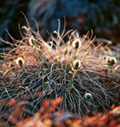
Caribou chow in the form of tussock cotton grass.
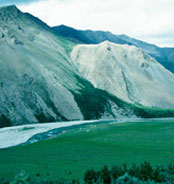
Ivvavik National Park.
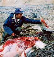
A Vuntut hunter preparing lunch.
Pretty soon, the caribou will come from over there, working their way around that low, broad mountain whose name translates to something like "where the muskrat got stuck." By late summer, as much as a third of the Porcupine herd, more than 35,000 animals, will hit the plain below the slope, their ankles clicking as they trot through tussocks of tundra that so closely match the gold and brown of their fur that they move like ghosts across the landscape.
"One time," says Gwich'in elder Dick Nukon, "I saw them crossing the river, and one caribou kept going back and forth. I saw she had a calf too small to swim. So I went and grabbed it, put it in my boat. Held it down there. Took it to the other side, and it jumped out, and I said to it, 'Don't come back when you're a big bull, or I'll have to shoot you.'"
The caribou will come from the west, where the sun hasn't set since we arrived three days ago. West is Alaska's embattled Arctic National Wildlife Refuge, but this is Vuntut National Park in Canada. Together with the even larger Ivvavik National Park directly to the north, it makes up a permanently protected area of 5,600 square miles.
Beyond bureaucratic designations like "national park" and "wildlife refuge," this part of the world is best thought of as the territory of the Porcupine caribou, which circulate in a vast migratory system over two nations and hundreds of miles as they have for millennia. And because of the caribou, these lands are also the territory of the Gwich'in people, who live in 19 villages scattered throughout the region on both sides of the border.
I've been invited by the Vuntut Gwich'in to spend the end of July on the land with them. That's their phrase, "on the land"; they say it the way I say "at home." Dick can name every creek and tiny hill, and he links them in his stories like a man drawing a careful and detailed map.
Being Caribou
Early in his first term, President George W. Bush declared his support for drilling in the Arctic National Wildlife Refuge, urging detractors to "travel up there and take a look at it" -- presumably hoping they'd decide it wasn't worth saving. Newlyweds Karsten Heuer and Leanne Allison took him up on the challenge, spending five months following the Porcupine caribou herd on its annual migration from Canada to the refuge's threatened coastal plain.
Beginning their journey in the Yukon Territory's Old Crow, the Canadian couple traveled more than 900 miles on foot and skis, fording frigid streams, scaling icy mountainsides, and evading hungry bears. In the film Allison made of their adventure, Being Caribou, the pair gladly endure their trials in exchange for the thrilling sight of thousands of caribou massing and moving through the vast, rugged landscape. --Jennifer Hattam
ON THE WEB
To learn more about Heuer and Allison's journey, the film Being
Caribou, and the book of the same name, visit beingcaribou.com.
But you need more than a map to get here. The only access is by floatplane, helicopter, boat, or, in winter, dogsled or snowmobile. Even where we get the helicopter, Old Crow in the Yukon Territory, is 50 miles past the middle of nowhere; Hillarie Zimmerman from Parks Canada tells me it's one of the most remote places in the whole country. It's a pretty village, 300 people living along the confluence of the Crow and Porcupine Rivers, no road out, the log-cabin-style houses decorated with antlers and satellite dishes.
Yet Old Crow is the big city compared with what happens in Vuntut. Although the Gwich'in themselves use the park as their backyard, the best estimate of annual non-Gwich'in visitors that Tourism Yukon can come up with is "maybe a handful." There is a river that's commercially rafted at the north end of the park, but most people don't know about it. A Parks Canada warden tells me that, as far as he can remember, the last non-Native, non-government worker to visit Vuntut was a guy who crashed his airplane inside its boundaries four years ago.
The GPS puts our camp at latitude 68o24'15.4" north, 100 miles above the Arctic Circle, as far north as I've ever been. When I told people I was going to the Arctic, they immediately thought I was headed into snow and ice and polar bears. But the landscape is impossibly lush. Our first days are hot and clear, with temperatures in the 80s and mosquitoes swirling in clouds so thick it's hard to see through them.
For a time, I'm able to drown out the bloodsuckers by blasting Bruce Springsteen on my iPod. Yes, I feel guilty about bringing modern sounds to this ancient, still land, but a few days of mosquito buzz is a reminder of why even the caribou can go insane up here. When the batteries finally die, the only hope is to get into the smoke from the small campfire we set up on a high spot in the creekbed. Over the next week, our water supply will vanish bit by bit; when the helicopter sets us down, the creek is a clear, cold flow, but by the last day we're walking half a mile to get a drink.
The creek banks are lined with low willows (standard joke: "What do you do when you're lost in the arctic forest? Stand up."), and beyond that we're ringed by mountains that look as though they've been glaciated, even though they never were. In fact, during the last ice age this area was ice free, part of Beringia, a transcontinental steppe where woolly mammoths cavorted with sloths the size of compact cars.
The steppe has given way over centuries to tundra, and the great thing about tundra is that the closer you get, the more you see. At one point, I sit and count 17 plants in a square foot of land: a saxifrage, reindeer lichen, an arctic poppy, and what I think is bearberry. But my ability to name the landscape soon ends. Are these two shades of red the same plant, and is that orange tint just another phase of this emerald green? I have no words for this richness. I roll tiny leaves in my fingers, crushing them, searching for the scent of Vuntut--something like wind stirring grass in an electrical storm.
Vuntut National Park was created in 1995 not only to preserve these vital 1,677 square miles for the caribou but also, according to the park charter, to "recognize Vuntut Gwich'in history and culture and recognize and protect their traditional and current uses of the park." As their ancestors have for thousands of years, the Gwich'in hunt caribou here, set muskrat traps, and simply come out to reconnect with their past. "It makes me feel like something belongs just to us," Lance Nukon, Dick's grandson, tells me.
The park includes the wetlands of the Old Crow Flats, which support more than a hundred species of bird, including a rare subspecies of peregrine falcon and short-eared owls. (Looking down from the helicopter as we fly over the wetlands, I see owls break above tarns, but from that altitude, who knows how big their ears are?) There are even disputed sightings of the Eskimo curlew: If it's not in the park where the wetlands meet the plains and mountains, it's extinct.
And twice a year, spring and fall, Vuntut is where the caribou are as they migrate to and from their calving grounds in Alaska on the northern edge of the Arctic Refuge's coastal plain, the so-called 1002 Area.
In Whitehorse, capital of the Yukon Territory, people talk about the 1002 Area as though it were a development dispute in their suburbs. The area is a minuscule part of the refuge, a couple thousand acres, but it also happens to be the place the Bush administration is determined to drill for whatever oil it might harbor. (Those plans were temporarily thwarted late last year when the U.S. Senate successfully filibustered a bill that included Arctic drilling. Everyone expects another attempt this year.)